climbing Haas Pass
Next on my list of New Zealand climbs was Haas Pass. In a way, this was a ride destined to end in tears. But more on that at the end.
Cycling New Zealand, a guide written by Scott Kennedy for Lonely Planet, describes the route from Makorora to Haast Junction, crossing the pass. However, if you look carefully at profile, shown on page 268 of the Sept 2009 edition, it's clear that only three data points were used for the profile between Haas Pass and Haas junction, covering 82 km. There's a point at the junction, of course, then one at 11 km from the pass at 100 meter elevation, then one at the pass itself, at what appears to be 560 meter elevation. So that's 460 meters gained in 11 km, an average of 4.2%. No problem, one might decide: this calls for an 11-20 straight block.
Heh.
I rode with Cara from our D.O.C. (pronounced "doc") campsite at Boundary Creek. Riding was effortless, it seemed, a good sign that there was going to be a heavy price to be paid later, with interest. it was around 15 km to the Makorora, then another 8 km to the Blue Pools, our goal. We locked our bikes, switched to our walking shoes, then did the wonderful little hike to the pools, which are surprisingly, well, blue for their depth. Perhaps the lack of particulate matter in the water results in reduced optical attenuation, increasing the vibrancy of the color. In addition to the view, the pedestrian suspension bridges are very nicely built. New Zealand takes its tramping seriously.
Back to our bikes, Cara set off back to the camp, while I went on to ride the pass. Of course high on my mind was Strava: when in foreign lands, K.O.M. opportunities abound.
The southern side is relatively easy, since according to Lonely Planet the real climbing here is only around 180 meters over 3 km. That seemed about accurate. It's a nice effort, but nothing epic.
The descent was surprisingly quick. Not only is it much steeper than the 4.2% indicated by Kennedy's profile, but the tailwind reduced the relative headwind, increasing my rate of acceleration on the straights. And occasionally I'd feel the instability of the shifting winds as I went around corners. As is often my practice, I took the descent carefully.
At the bottom, I wanted to make sure I'd cleared the Strava segment, so continues onward effortlessly.
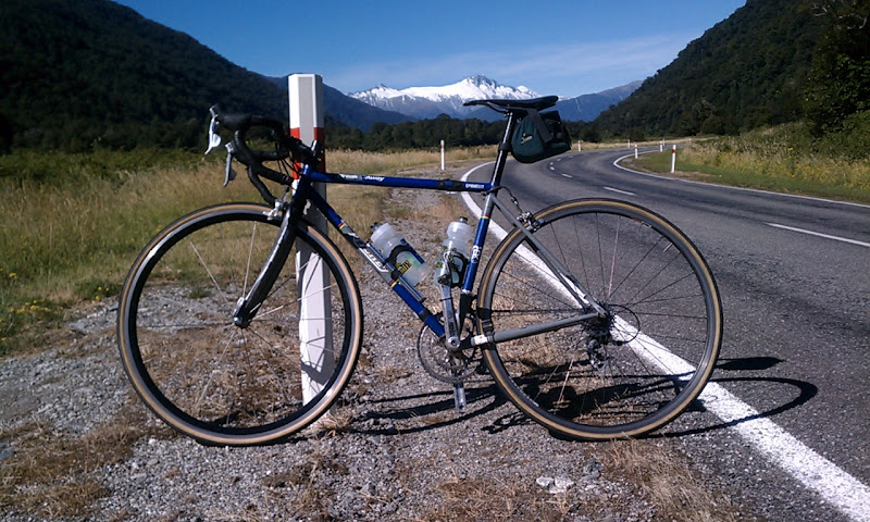
I turned a corner to a spectacular view of distant mountains. I stopped and took a photo. A look at my phone showed the distance so far: 44.5 km. This would be a good time to turn around. So after a few pictures, I turned.
Instantly it was made clear to me why the riding on the flats had been so effortless: I was going straight into a brisk headwind. Ah, well...
The climb began right past the lookout for McFarlane Falls. And it was instantly steep: the grade meter was definitely pegged above 10%. At least the wind was less here due to the mountain's shelter.
And what a climb! Views of the gorge on the left, waterfalls cascading down the sheer cliff on the right, the occasional cattle guard to keep things interesting, all cooperated in keeping my mind off the effort. The road snaked along, rising above the Haas river, until it left the river for the final climb to the pass.
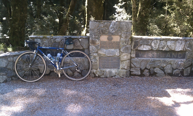
I kept the effort up here, increasing it when I saw the opposite-facing sign welcoming travelers to Westmore, not letting up until I cleared the simple pass sign on the left, the older, stone-etched county line divider on the right. I felt this was a Strava-worthy effort.
After the rapid descent came the long run back to Boundary Creek. Near Cameron Flat I looked again: 59 km covered, so 30 km remaining based on my turn-around. It was the last time I would look at the distance reading on the unit, but I knew at least I had both crossings of the pass in the bag. No other significant climbs remained.
So 30 km left, but what a 30 km... winds were occasionally tempered by lines of trees which marked the boundaries between sheep-grazing fields, but otherwise, it felt as if every pedal stroke was being heavily taxed: 2/3 for the wind, 1/3 for forward progress. A part of my issue was likely food: I hadn't brought enough.
I finally reached Makorora and it's surprisingly expansive Cafe/General Store/Information Center, which I entered after parking my bike outside. I resisted getting a $5 smoothy (well, fruit-flavored milkshake, but I assumed a smoothy could have been procured) and took the $1.50 banana instead: it was only 15 km further. I stopped to check on the Siberian Experience, a combination plane ride - hike - jet boat adventure. $320/person.... I decided really the hike was the part of it I wanted, and that can be had gratis. So off I went.
The final kilometers opassed, as they will, although much slower than wanted due to the wind. I'd hoped for a banana-induced kick, but none was granted. But turn over the pedals enough time and a goal is reached, and here I finally saw the 4 km to go sign, then eventually the campground itself. I decided I've gotten headwind-soft living in San Francisco after my time in Austin, Texas. I let the headwinds beat me down. Cara, by the way, later told me she hadn't minded the headwinds at all.
Here's where things went to tears: there was a problem with Strava and, although my app had been showing full distance, only the first 18 km of my ride had been recorded. These had been ridden at a relaxed pace with Cara, of no Strava interest, so I didn't bother saving them. My climb efforts were lost in the void of unrecorded data, the place we call /dev/null.
I was stunned. Shocked. A small bit of my life drained away in a spasm of despair. Surely I could have avoided this... had I not lost my Edge 500 before the trip... had I replaced it before the trip... The Strava app is great, but there's no beating specialized hardware for reliability.
Ah, well. There would likely be no further climbs of Haas in this life, but at least I had the memory of what was a surprisingly challenging climb, especially given Lonely Planet's neglect. Indeed, this is just one of many examples where the book fails to do justice to New Zealands fantastic cycling roads. I hope a better cycling guide for New Zealand is published soon. John Summerson, are you listening?
Postscript: Later, in Queenstown, I found a much improved guide to New Zealand cycling: the domestic "Classic New Zealand Road Rides" by Jonathan Kennett and Kieran Turner. It's a bit pricey at NZ 39.90, but the route profiles and descriptions are clearly superior.


Comments